To honour Richmond’s 200th anniversary, we will be posting factoids about our rich history. Over the next year you should expect to see 200 pieces of information that you may or may not have already known. The topics included in this post are: #1. Reasons for settlement #2. Building a “planned” community #3. The soldier/settlers #4. Town & park lots #5. Jock River
If you have a question about the source of a factoid please contact us.
Factoid #1. In 1818, fearful of an American invasion, the British government decided to settle disbanded soldiers in the area between Perth and the Ottawa River and establish a depot at a new centre called Richmond. From there administrators would oversee the settlement of Goulbourn, Huntley, and March Townships as well as parts of Beckwith and Nepean. The whole area was referred to as the Richmond Military Settlement.
Factoid #2. The settlement was to be administered from the village of Richmond a “planned” community. In 1818 the British military used the same template it had used for Perth – a rectangular grid of perpendicular streets superimposed on the landscape. The template included a river running diagonally across the grid. The military decided that the “centre” of the village should be the block bordered by Cockburn St. on the west and the river on the south. Here they built a depot to distribute supplies to the settlers and a school. See below the plan compiled by deputy provincial surveyor Joseph Fortune. He coloured the administration lands pink.
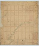
(Plan of the VILLAGE of RICHMOND situate in the Township of Goulburn district of Johnstown province of Upper Canada. Surveyed under Instructions of Thomas Ridout Esquire Surveyor General) Ref. Archives Ontario Plan 288 H20
Thanks to George Neville for sharing this digital copy.
Factoid #3. Col. George T. Burke, the Superintendent of the Richmond Settlement, acted as land agent. He oversaw the distribution of land to the soldier-settlers who were mostly former members of the disbanded 100th Regiment. Burke’s influence had a lasting impact on many settler families. Even though each private received 100 acres (and higher ranks more) one of the determining factors for success was the quality of the land one received. How much was marshy or rocky? How much was arable? Some soldiers used the Richmond Settlement as a starting point and quickly moved on to other more appealing townships or towns with greater opportunities. Even in its infancy Richmond was not only a place to come to, but also a place to come from.
Factoid #4. In Goulbourn Township settlers usually received 100-acre parcels of land, but in the village one might be given one or more “town” or “park” lots. Inside the area bounded by Perth, Queen (Charlotte), Ottawa, and King Streets were the blocks containing the town lots. Each block had six 1-acre lots. It was felt that one acre was enough land for the house, barn, sheds, garden and orchard required for successful village life. (The blocks facing Ottawa St. had 8 acres rather than 6.) Outside the perimeter stretched the 10-acre park lots. These were intended to provide estates for the affluent settlers but in the early decades the lots had few buildings and if cleared were used for farming.
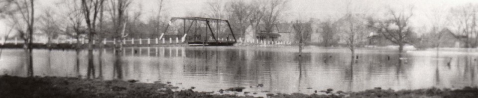
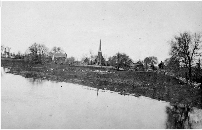
Factoid #5. Old maps of the area show that Richmond’s river was originally called “Jacques” supposedly after a French Canadian of that name who drowned in its waters. After the village was named Richmond in honor of the Duke of Richmond (who had just been appointed Governor-General and died close to the banks of the river), the name was changed to “Goodwood” as that was the name of his English estate. Locals continued to use the original name and over time the spelling was anglicized to “Jock”. Flooding was always a problem as the village was low lying, swampy, and crossed by at least 3 creeks. The first photo, below, taken near the corner of (Royal) York and McBean Streets shows the extent of the problem in 1925. The second photo with St. John’s Anglican Church the background shows what we now call the Arbuckle Creek in full flood. Photos are from the files of the Goulbourn Township Historical Society.